Noak Bridge Nature Reserve - maps
Postcode SS15 4JE - Google Map - Noak Bridge - Streetmap - Noak Bridge
First Buses - Route 300 - bus stops - Bridge Street and Eastfield Road
see below for travel directions by road
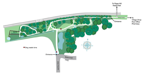
[ click on the map to see the full size image ]
NOTE: This map is upside down, with North at the bottom
~~~~~~~~~~~~~~~~~~~~~~~~~~~~~~~~~~~~~~~~~~~~~~~~~
map of the Reserve with North at the top

directions by roadfrom Basildon, take the A176 north until the junction with the A127 - take the 2nd exit (straight ahead) at the roundabout immediately before the road goes under the A127 - at the roundabout immediately after the road has gone under the A127, take the 2nd exit (straight ahead) (sign-posted to Noak Bridge) along South Wash Road (which becomes Wash Road) - for Eastfield Road turn right at the 3rd mini roundaboutfrom Billericay, take the A176 South until the junction with the A127 - at the roundabout immediately before the A127 take the first exit (sign-posted to Noak Bridge) along South Wash Road (which becomes Wash Road) - for Eastfield Road turn right at the 3rd mini roundabout from Barleylands, go south down Barleylands Road - at the T-junction where it meets Wash Road turn left - almost immediately afterwards turn right into Eastfield Road from Southend, take the A127 west until the junction with the A176 - follow the slip road to the roundabout and take the first exit (which leads under the A127) - at the roundabout immediately after the road has gone under the A127, take the 2nd exit (straight ahead) (sign-posted to Noak Bridge) along South Wash Road (which becomes Wash Road) - for Eastfield Road turn right at the 3rd mini roundabout from London, take the A127 east until the junction with the A176 - follow the slip road to the roundabout and take the 3rd exit (sign-posted to Noak Bridge) along South Wash Road (which becomes Wash Road) - for Eastfield Road turn right at the 3rd mini roundabout OS grid referencesTQ696902 - A127 EntranceTQ697903 - bench at end of West Woodland Walk TQ697903 - High Ridge (west part) - Noak Steps & Spanish Steps TQ698903 - West Woodland Walk TQ698904 - Prewers Pond TQ699903 - High Ridge (east part) TQ699904 - Cleared Scrubland (and grassy area on north side of path) TQ699905 - Plotlands Way TQ699906 - Churchfield Road Entrance TQ700904 - Storage shed TQ700905 - East Woodland Walk (west part) (from the central area) TQ701902 - Fox Pond TQ701905 - Puckles Pond TQ702905 - East Wodland Walk (east part) & Dragonfly Loop TQ702989 - entry to East Meadow TQ703905 - East Meadow and eastern edge of Reserve TQ703906 - Meadow Pond TQ696903 - SE corner of Reserve TQ696902 - SW corner of Reserve TQ703907 - NE corner of Reserve (end of stream) TQ704906 - SE corner of Reserve |
home | map | about | wildlife | galleries | society | links | Facebook | Instagram